Local governments and communities regularly make decisions about how to use land within their borders. But when it comes to the ocean, the concept of spatial planning gets a lot more complicated.
“In the ocean you have to manage for different uses, but you have to do it in three dimensions: length, width, and depth,” says Sylvain De Guise, associate professor of pathobiology and director of the Connecticut Sea Grant College Program. “For example, will it matter to a surfer if there are energy-producing turbines on the sea floor below?”
The idea of managing various – sometimes conflicting – uses of the ocean is gaining steam as the concept of marine spatial planning, which attempts to identify ocean areas best suited for different human uses to sustain economic, natural, and cultural resources.
The topic was the focus of a May 5 workshop at UConn’s Avery Point Campus between the Connecticut Department of Environmental Protection and the New York Department of Environmental Conservation, as the first step in developing a marine spatial plan for Long Island Sound.
“What if one community wants to establish an oyster restoration project, and another wants to develop a marina?” De Guise questions. Under current management, he says, these issues would be dealt with on a case by-case basis, which often leaves out the interests of particular groups.
Led by the Connecticut and New York Sea Grant offices, the workshop cast a wide net to involve the many stakeholders who use the Sound. Representatives of commercial and recreational fishermen, lobstermen, aquaculturists, boat captains, maritime traders, engineers, and conservation groups attended the conference.
“Unofficial ocean zones have existed for a long time,” says Bob Pomeroy, professor of marine sciences and the workshop’s organizer. “Marine spatial planning will organize this process.”
Pomeroy says he hopes the workshop will help make stakeholders more aware of marine spatial planning. “It was an educational meeting to get people thinking about the process, the next steps, and whether and how to move forward,” he says.
De Guise says managing all the different interests across a highly-used water body split in governance between two states is nothing short of a challenge.
“In the Sound, there are federal laws and state laws, and a line in the middle representing Connecticut and New York,” he says. “Fish and boats cross that line all the time. So you have to take into account the shared governance, and include both sides.”

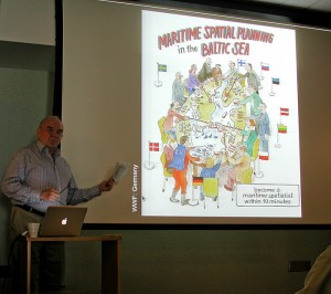
The workshop featured guest speaker Charles Ehler, an expert in marine spatial planning. Formerly at NOAA for 27 years, Ehler now acts as a consultant to various European governments and UNESCO’s Intergovernmental Oceanographic Commission on coastal and marine spatial planning issues. European countries have been engaging in marine spatial planning for about 15 years, says De Guise, so Ehler’s input was particularly welcome.
In the U.S., several recent reports, including an annual NOAA guidance memo and a report by the Obama administration’s oceans task force, have brought marine spatial planning to the forefront of ocean management techniques, and placed pressure on states with ocean borders to begin using these techniques to manage their coastal areas.
De Guise sees the roles of the Connecticut and New York Sea Grant programs as facilitating talks among the Connecticut Department of Environmental Protection, the New York Department of Environmental Conservation, and stakeholders. As with any new concept, he acknowledges that there are competing interests and change will likely happen slowly. But if you don’t start, you never get anywhere, he points out.
“This workshop started with the current problems and conflicts, and proposed a solution mechanism that is known to be successful elsewhere,” DeGuise says. “It’s the first step toward a shared vision for the Long Island Sound.”


